Bright spots and black nights
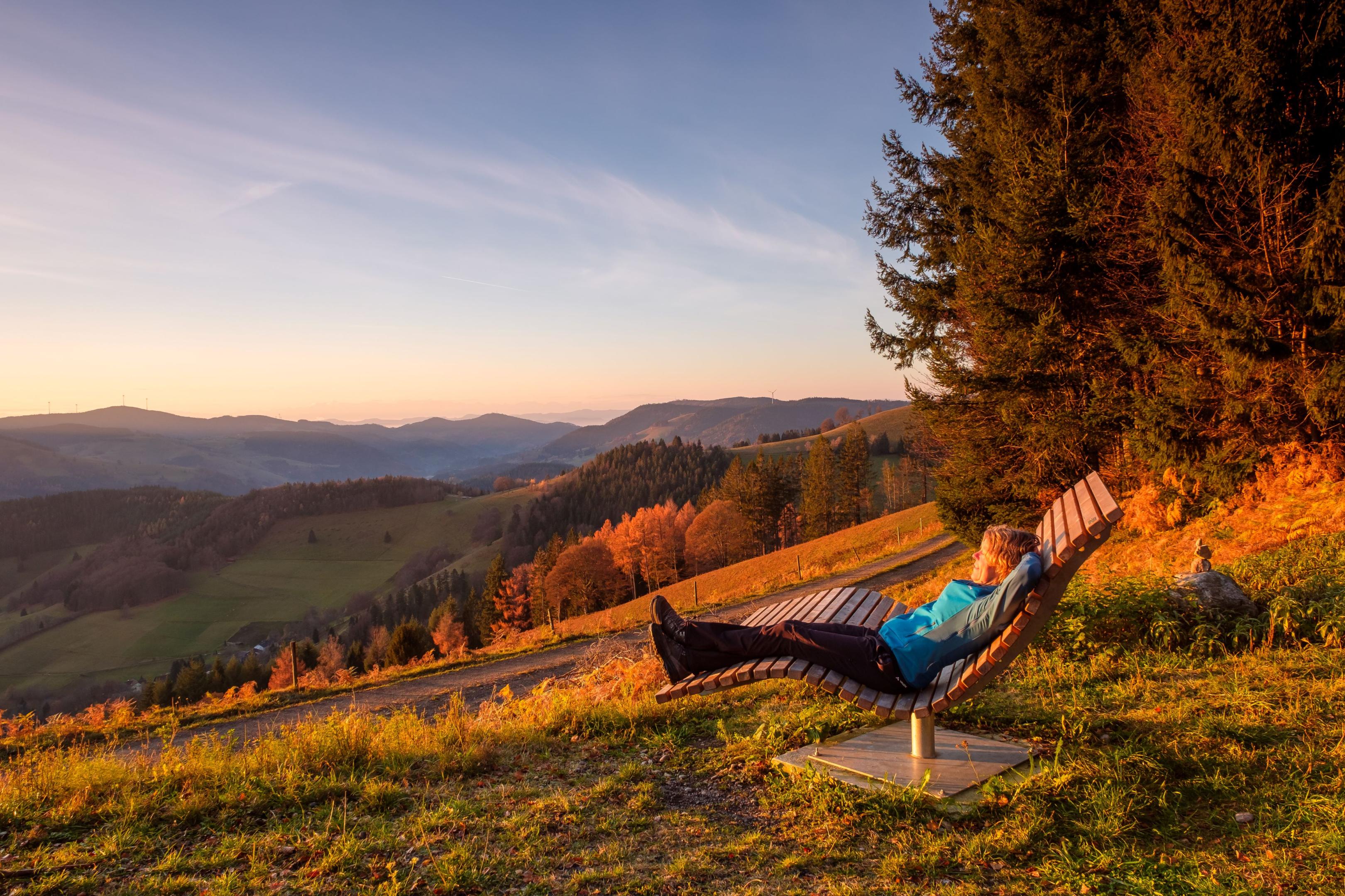
Recently, people have increasingly been looking for quiet corners. All the better when they are practically on your doorstep. A piece of the southern Black Forest is hidden away in the hinterland of the Grosses Wiesental. Of meadows and forests, alpine views and sky loungers...
It was dark, the moon shone brightly.... It haunted my mind on that balmy evening. Everyone probably knows the age-old joke poem, a poem characterized by contradictory statements, paradoxes. The world is full of paradoxes. So is the debate about climate change.
As this text is being written, a climate conference is taking place in Dubai. The largest private jet meeting in the world, according to the Internet. But how are the 70,000 participants going to reach an agreement if not even a few politicians can?
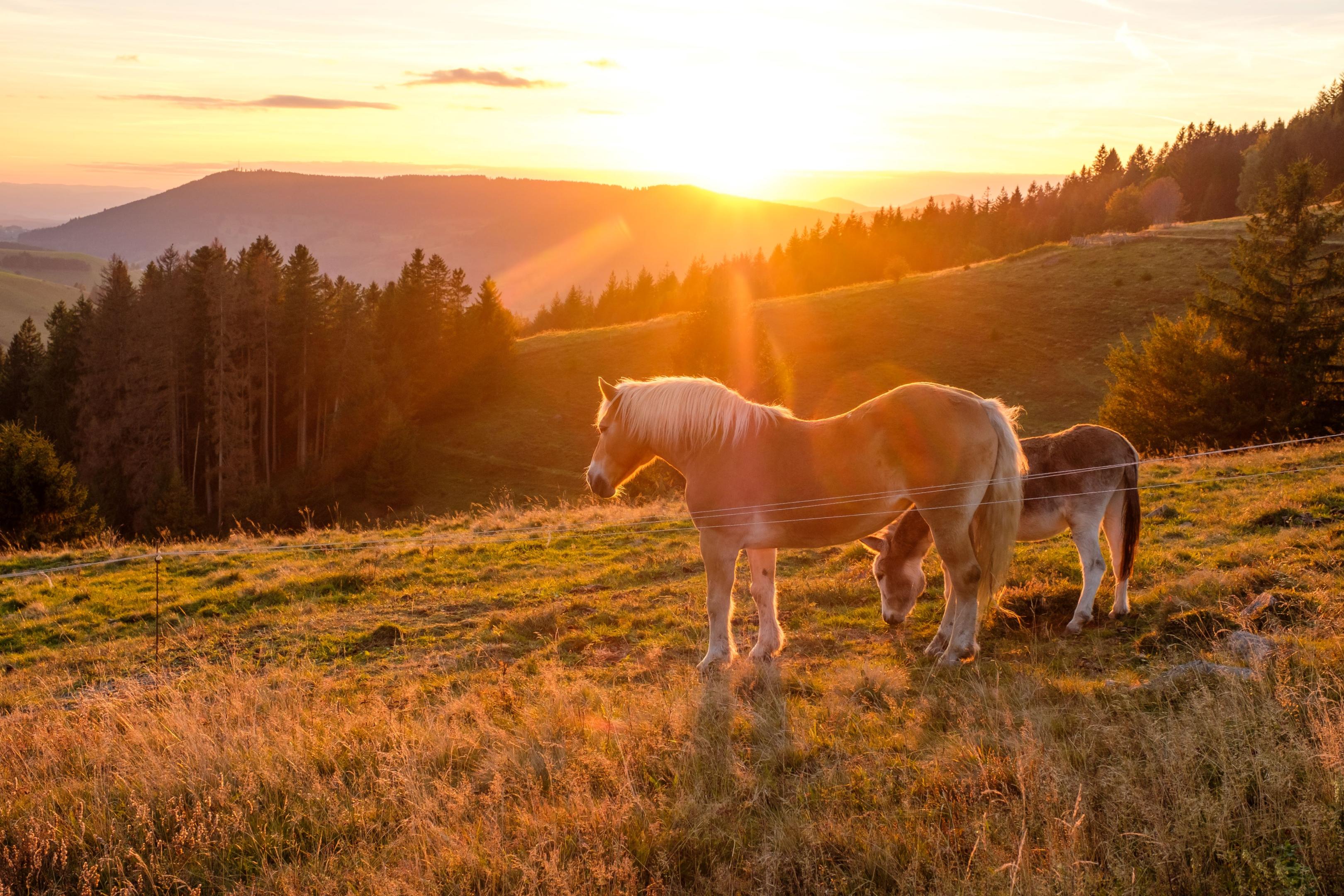
Saving energy on the one hand, and an insane waste of energy on the other. Light pollution is right at the top of the list. Street lighting is so excessive that it is no longer possible to sleep soundly at night without darkening the windows. A look outside when you go to bed calms this fear. The Black Forest lives up to its name. Treetops sway in the wind. It would be hard to imagine that there are houses between them if the moon wasn't shining. At the stroke of midnight, all outdoor lighting goes out in Menzenschwand. Until the early hours of the morning, the village lies in pitch darkness and rested, friendly faces greet the day. Dieter and I agree that we wanted to stay here longer. We had planned a 4-day trek to explore deep into the southern Black Forest, on paths away from the mainstream. To places where the world still seems to be in order.
On the back roads
Our start three days ago begins at the Wiese. That's the name of a river here. It has its source on the Feldberg, the highest mountain in the Black Forest, and flows into the Rhine after 58 kilometers in Basel's Rhine harbour. Our starting point: Schönau, the largest municipality in the upper Wiesental and the birthplace of Jogi Löw. The climatic health resort is easy to reach by public transport from Freiburg or Basel. And if you pick up a Konus guest card at your accommodation, the return journey is free. It doesn't get any better than that.
How many times have I chugged through Schönau in the family car, taken the mainstream to Feldberg or Belchen, complained about the traffic with my parents... and found the small country town in the upper Wiesental to be a rather bland thoroughfare. You could have simply taken the bus to Schönau and relaxed right next to the river on the jungle path and been pretty much on your own. This would also show that Schönau only seems bland when you drive through it. Alemannic flair at the village gossip on Friday, the market day under the spell of the stately village church. It is a neo-Gothic cultural treasure, often referred to as the "cathedral" of the Wiesental. Its bell tower rises 90 meters into the air and is the tallest in the district of Lörrach. Just a few steps away from the busy thoroughfare, you can take a surprisingly tranquil stroll through various alleyways, such as Ledergasse, where craftsmen had already settled in the 13th century when mining began to flourish in the "beautiful Au".
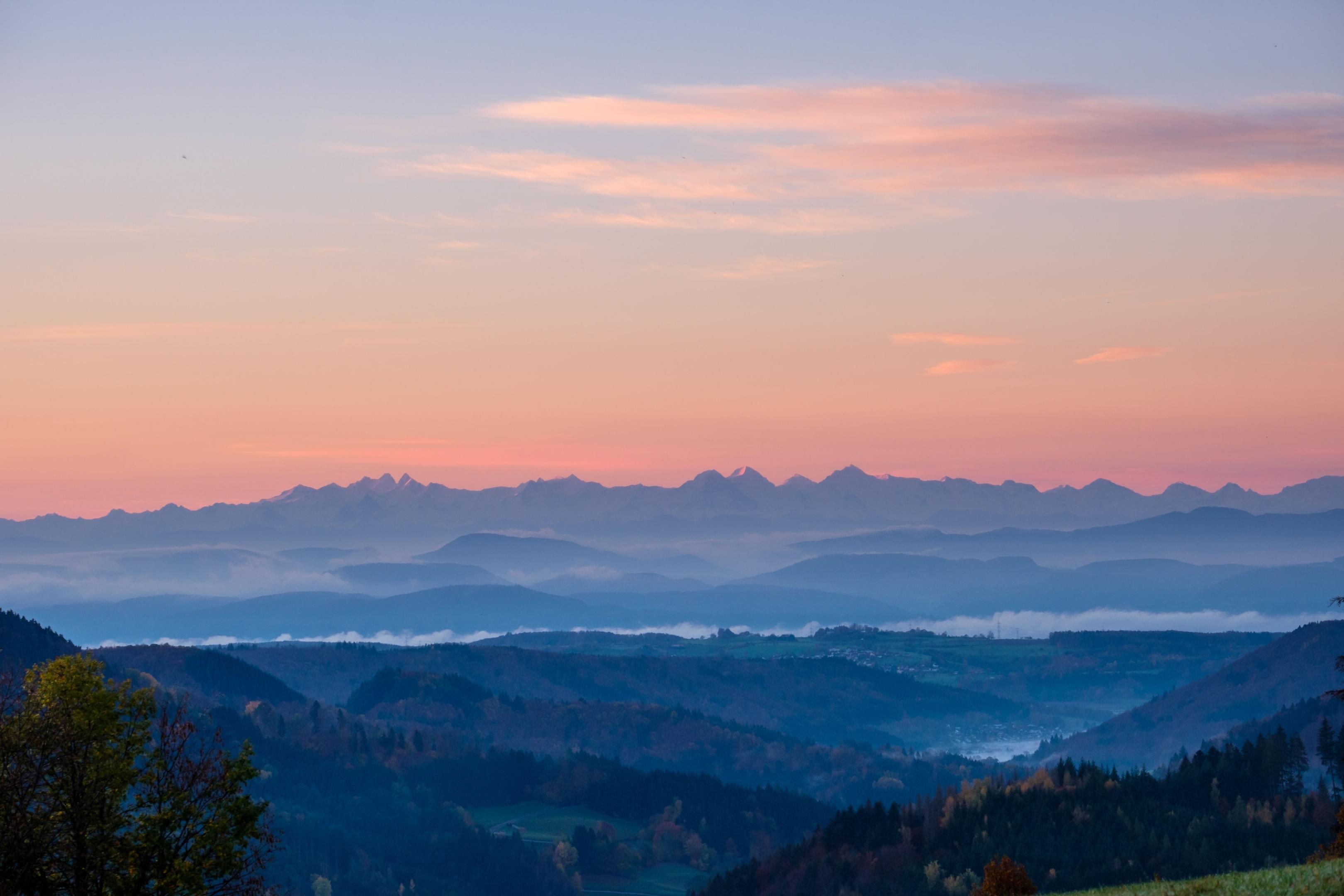
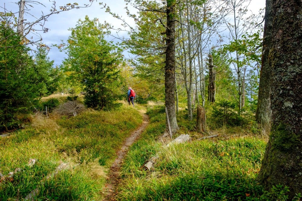
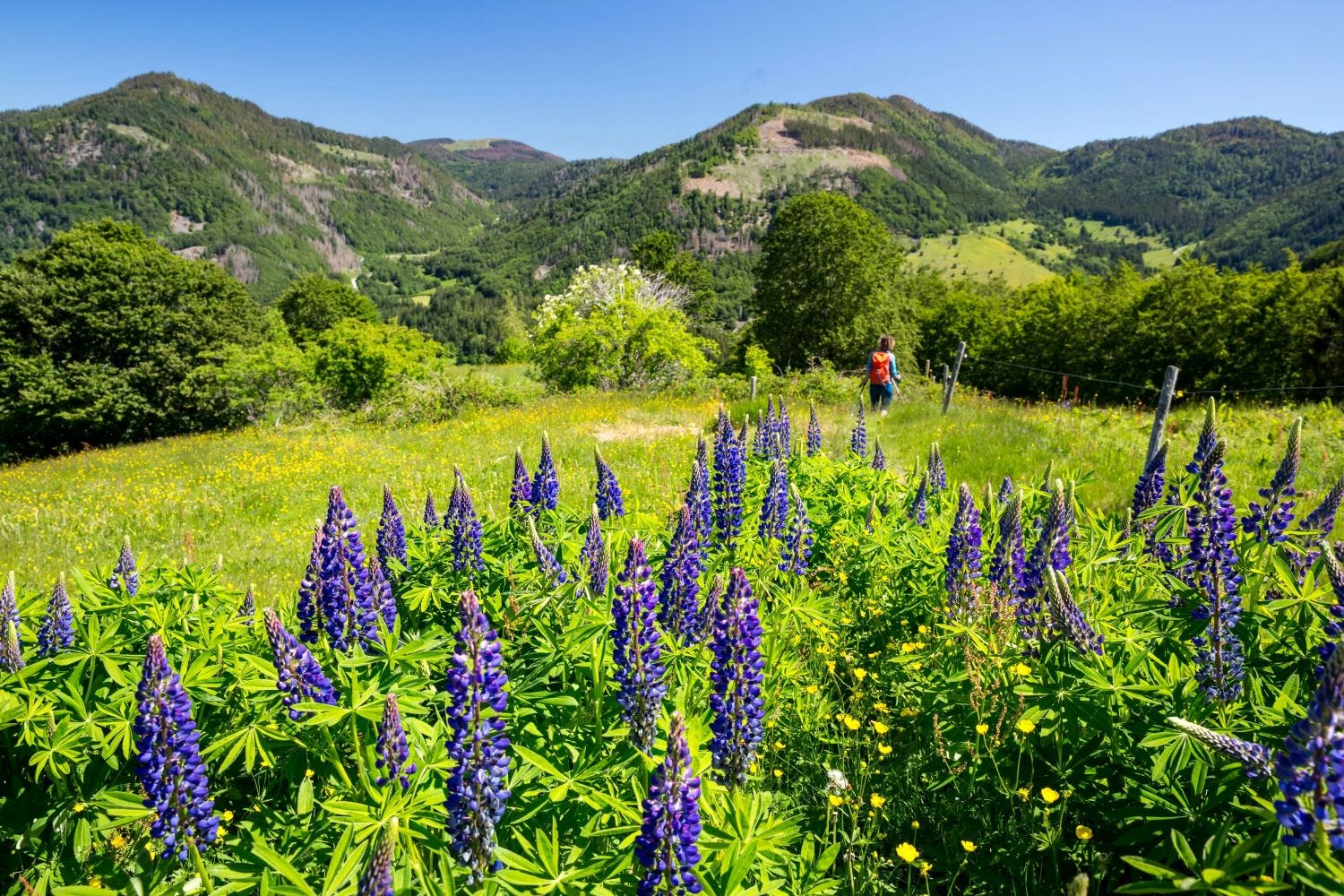
Six decades ago, you could even have traveled to Schönau by train, according to an information board near the Wiesen bridge. This narrow-gauge railroad was called the Todnauerli back then: a cozy steam locomotive that ran from Zell to Todtnau. it was shut down in 1968 because there were more and more motorists on the road. And then suddenly the vanished station catches the eye, the stately building converted by the Riegel brewery. Barely five minutes later, the primeval forest trail branches off into the Flüh forest, which has been left to its own devices since 1970. This is a relatively young forest, but it is a wonderful place to observe how nature is reclaiming former farmland. For a long time, the Black Forest was bare because far too much was cut down: the mining industry needed the raw material, but the city of Basel also ate up firewood and paid the best prices for it. There are still countless open spaces that characterize the southern Black Forest in particular, including the Große Wiesental. The Holzerkreuz, the open hilltop above Schönau, is the starting point for a pleasurable panoramic hike. A sky lounger invites you to let your gaze wander in a relaxed horizontal position from the Feldberg over the Belchen, the two highest peaks in the Black Forest, to the Alpine ridge. Beneath the ribbon of glaciated peaks undulate the rolling hills of the Grosses and Kleines Wiesental, a mosaic of pastures and forests, above which hermit farms with mighty hipped roofs are scattered.


At a snail's pace to slow food
Reveling in the views, we hike along the Dornwasen panoramic trail to Herrenschwand. Not a long route and therefore ideal for the day of arrival and for migrating.
The small village nestled on a high plateau seems remote, like a place where fox and hare say goodnight. But it's not that people here have slept through progress. Rather the exact opposite: a successful fusion of retro and modern, which comes together in the Hotel Waldfrieden. The greetings from the kitchen are reminiscent of antipasti - you don't even have to travel to Piedmont, the country of origin of slow food. For example, "Black Forest sushi" - sushi rice with trout and Black Forest ham; char in wafer-thin crêpes with pumpkin confit; parsnip soup in an espresso cup, vitello tonnato...
Volker Hupfer, master chef and junior chef, gives his grandmother's recipes a modern, often exotic touch. The 39-year-old is the fourth generation to run the family business. His creations also impressed Slow Food - a movement that originated in Piedmont - and they included the "Waldfrieden" in their gastro guide. Further awards followed, such as the green Michelin star Bib Gourmand, which stands for regional, fresh cuisine at fair prices. Honest cuisine, lots of vegetarian and vegan dishes, and so good that you don't even miss the meat, we think. We had previously sweated and relaxed in the spa house next to the main building. The modern building made of glass and wood, which is adapted to the traditional architecture, was awarded the "Baukultur Schwarzwald" architecture prize in 2016 because it blends harmoniously into the landscape. On a stroll through the village, we discover not only the Kneipp path by the stream, but also the Rummel-Sepp square on the edge of the forest. Renate Rummel is lifting a crate of beer into the fountain and then watering the flowers by the schnapps house. She regularly checks that everything is in order. Her father-in-law loved this spot: the wide view over the landscape, the silence, accompanied only by the sound of water and birdsong. After his death, the idea arose to continue this for him, says the florist. A wooden bench now invites hikers to muse over a Black Forest beer or a local schnapps. Hardly anyone forgets to pay into the till. Thank goodness for honesty that there are such lovingly furnished places.
Tower climbs and glacial cirques
The wind whistles across the plateaus as we set off on the next stage in the morning. We are heading over the Hochkopf to Bernau. At the Weißenbachsattel, the view opens up to the south and the foehn shows what it is capable of. The band of the Alps on the horizon is unbelievably clear. The view from the Hochkopfturm, which is reached relatively quickly, is even better. A pretty wooden structure that allows you to look in all directions from the top floor. There was already a hut here in 1898, a simple wooden shed that was intended to offer hikers shelter and later had a viewing platform above the roof, as a historical photo on the information board beautifully shows. After the First World War, the first tower was built in 1925/26. From here, we have a wonderful view of the hiking route ahead of us. The Blößling will be our next summit, with a fine ridge hike in between. We follow the red diamond of the Westweg, which is also a section of the Turmsteige. The trail winds its way through loose mixed forest full of secluded meadow spots. Everyone will probably smile at the Ledertschobestein, the answer to the riddle hangs on a stately spruce tree, in case anyone is wondering what the Alemannic word Ledertschobe means. We pass to the west of the Hoher Zinken through to the Präger Eck. Below us lies the wide Präger glacier basin. We google it and learn: "Most recently during the Würm glacial period (115,000 to 10,000 years ago), six glaciers collided here - unique for German low mountain ranges. In the high glacial period, the ice reached a thickness of over 500 meters in places, the maximum value for the Black Forest during the Würm period." What remains is a treasure trove of glacial shapes, rounded humps and moraine walls. We climb one of them.
From the nudist summit to the bourgeois horns
My girlfriend calls it the nudist summit. You want to expose yourself up there when the sun is burning and there's hardly anyone around anyway. But the name comes from bare or treeless. As we already know from the primeval forest trail on the first stage, the Black Forest was badly damaged by deforestation from the 16th century onwards. There are still many bare areas around the summit of the Blößling. Not so the descent path. It leads us through the forest from Blößling down to Wacht, where we meet the road between Präg and Bernau. We stay on the red diamond trail, although there are also more direct descents into the Bernau valley, pass to the west of the Ecklekopf to the Hofeck and climb the Herzogenhorn, the second highest peak in the Black Forest. Two sky loungers allow you to make yourself comfortable. The view can sweep far and wide, with the Feldberg to the north and the Bernau valley to the south at your feet, with the Krunkelbachhütte under the Spießhörner, our destination, to the left. Bernau consists of ten districts, which actually look like small villages in their own right and are spread over the eight-kilometre-long high valley. So if you have chosen accommodation in Bernau, you should know exactly which district it is in if you don't want to extend your hike unintentionally. It smells of herbs, flowers and honey. Bees buzz through the heather on the bare hilltop, which juts out of a wooded crown like a bald head.
During the pandemic, the Herzogenhorn in particular made headlines because camp parties were held here. However, this is a nature reserve, which means that camping is not permitted. And early in the morning, the "outdoorsmen" had to deal with rangers and pay a penalty fee. Not a nice way to wake up and of course the beautiful sunrise was gone. Yet the Krunkelbachhütte is relatively close by, where you can even treat yourself to a dip in the hot tub in the evening.
Wondrous springs and magical places
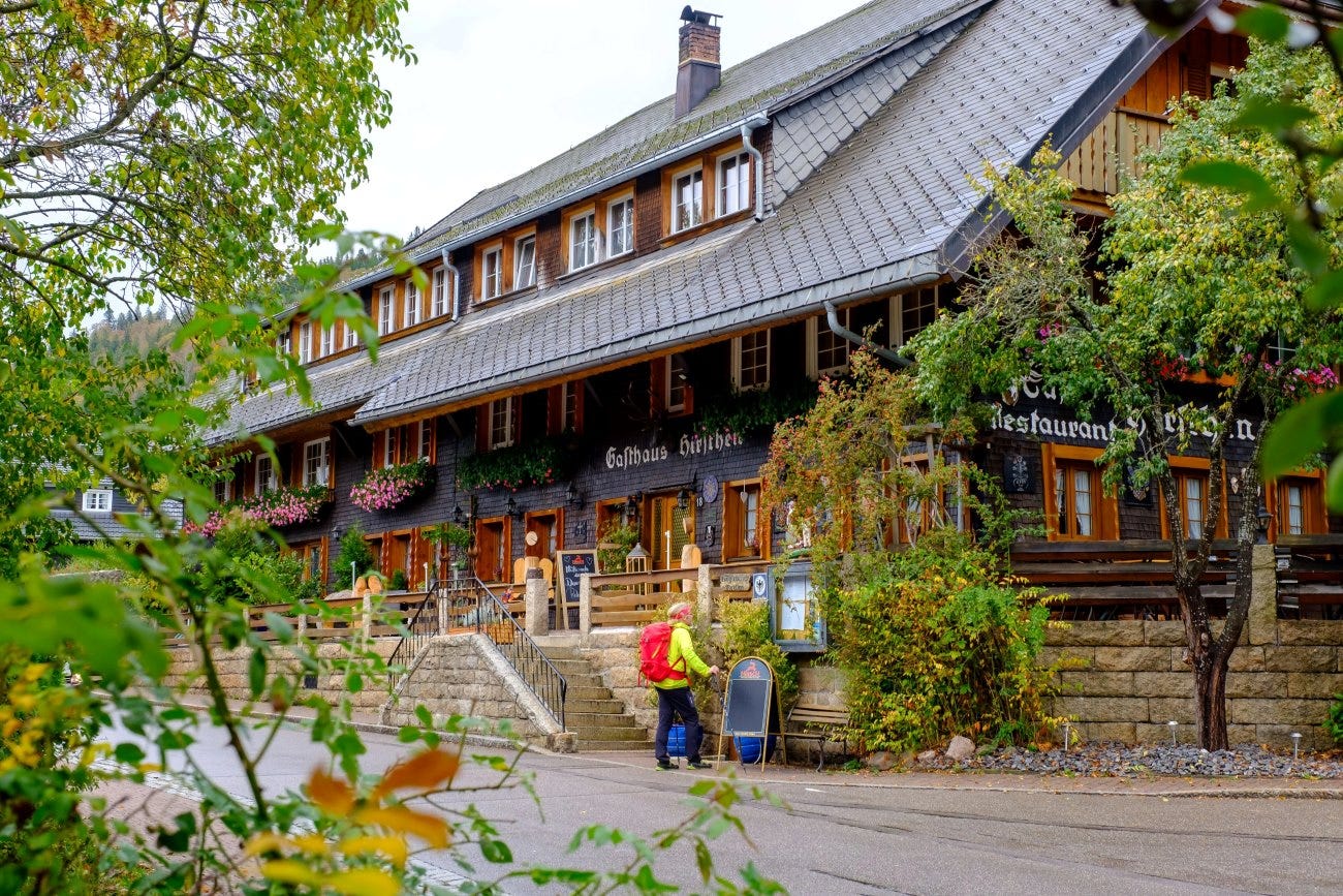
Via the Hochtal Steig, a recently created premium trail, we explore the next ridge that separates the Bernauer Tal from the Menzenschwander Tal. Sky loungers have been installed at the most beautiful spots, such as the Kleiner Spießhorn or the Riggenbacher Eck. At the former, you can look through the so-called Viscope, a very special telescope that automatically displays mountain names and their altitudes. This eliminates the guessing game as to which of the Alpine peaks, some 140 kilometers away, is the Finsteraarhorn or the Blüemlisalp. Almost everyone agrees on the Eiger, Mönch or Jungfrau. Even from the Kleiner Spießhorn, the distant view extends as far as Mont Blanc. At the Kaisereck, we turn off into the Menzenschwander Tal valley and follow the yellow diamond into the Vorderdorf village. Ancient Black Forest farmsteads, their hipped roofs almost kissing the ground. The youth hostel is even housed in one of them. However, we have opted for the "Hirschen" in Hinterdorf, which we reach via the eastern variant of the Albsteig. Another Black Forest house straight out of a picture book. You feel incredibly safe under these imposing roofs with their cozy parlours, where the "Kunst" (the Alemannic word for tiled stove) is usually heated up in cool temperatures and invites you to warm your back and bottom. Wonderful for tired muscles. But they can also relax in the radon revitalizing bath just a few minutes' walk away. The friendly staff will put you in a good mood. The spa has an appealing family atmosphere. Not a huge facility with all sorts of bells and whistles, as in fun pools. You glide weightlessly through the water and can let your gaze wander over the idyllic valley or the sky. Managing Director Jürgen Längin explains that there has never been any radon in the fluoride-containing mineral water. The radon therapies from the past were carried out in tubs. That's why they want to move away from the name and leave it at Revitalbad in future. However, the story is persistent, with guests repeatedly asking about the radon. An idyllic path leads to the Barbara Spring, which feeds the bathing pool, and the radon spring at the head of the Krunkelbach Valley. In the 1960s, a Dutch mining company discovered uranium ore and initially only granted permission for trial prospecting. Instead, commercial mining began until resistance finally emerged in the 1980s and headlines focused on the remote village of Menzenschwand. Der Spiegel wrote: "The best uranium deposits in Europe are in southern Germany. Mining will pollute the landscape and the environment, citizens are preparing to protest." in 1989, the tunnels had to be flooded and the mine filled in. A blessing for the unique nature reserve.
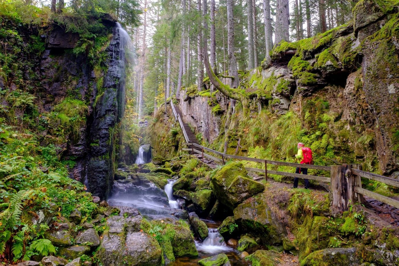
Where bells ring differently
What a paradisiacal corner back there in the Krunkelbach valley. Chamois, which you would hardly expect to see in the Black Forest, can be observed in the rocks. From the ten animals originally released in the 1930s, a sizeable population has developed. Little bells tinkle across the green meadows on the valley floor. Goats keep the landscape open and ensure botanical diversity. Footbridges and steps lead you into the wild and romantic gorge with the waterfalls of the Menzenschwander Alb. A place of power, like the Gisibodenalm, where we will spend the night tomorrow. For now, it's time to enjoy the "Hirschen". The Oberstüble was once reserved for the parish priest, who arrived once a week by horse and carriage from St. Blasien for the Sunday sermon. The bells of the old village church opposite no longer chime because the parish church has moved into the countryside. St. Blasien Abbey, which commissioned the construction of the "Hirschen" in 1733, allows its flock to spend both dark and quiet nights here.
Text and photos by Iris Kürschner
Helpful information
www.schwarzwaldregion-belchen.de
www.naturpark-suedschwarzwald.de
Arrival and departure
From Freiburg by bus to Schönau. From Basel by train to Zell, where you change to the bus to Schönau. If you stay one night or more, you will receive the Konus guest card, which includes free use of public transport and a free return journey.
Accommodation
1. Stage: Naturparkhotel Waldfrieden, Herrenschwand, www.derwaldfrieden.de.
2. Stage: Krunkelbachhütte, tel. 07675 929162, www.krunkelbach.de. Bernau has a good selection, recommended: Landgasthof Bergblick in Bernau-Dorf, www.bergblick-bernau.de.
3. Stage: Menzenschwand offers a good selection, recommended: Hotel Hirschen in Hinterdorf, tel. 07675 9299930, www.hirschen-menzenschwand.de; youth hostel in Vorderdorf, housed in an old Black Forest house, tel. 07675 326. For tent fans there is also a trekking camp, in a wild and romantic location near the quarry in the forest, booking platform: www.trekking-schwarzwald.de.
4. Stage: Gisibodenalm mountain inn, closed Mon/Thu, tel. 07671 9925068, www.gisibodenalm.com.
Route
1. Schönau - Holzer Kreuz - Dornwasen-Panoramaweg - Herrenschwand, 10 km, 3 hours.
2. Herrenschwand - Weißenbachsattel - Hochkopfturm - Ledertschoben - Präger Eck - Blößling - Wacht - Hofeck - Herzogenhorn - Krunkelbachhütte, 17 km, 6 hours.
3. Krunkelbachhütte - Spießhorn - Kleines Spießhorn - Kaisereck - Menzenschwand-Vorderdorf - Menzenschwand-Hinterdorf, 9 km, 2.45 hrs.
3. Menzenschwand-Hinterdorf - Geißenpfad - Albschlucht-Wasserfälle - Radonquelle - Schutzhütte am Finsterbühl - Krunkelbachsattel - Glockenführe - Bernauer Kreuz - Gisiboden, 11 km, 3.30 h. With detour to Herzogenhorn in total 4.15 h.
4. Gisiboden - Hasenhorn - Todtnau, 7 km, 2 hours.
Maps
The best maps are provided by the Black Forest Association at a scale of 1:25,000, W257 Schönau im Schwarzwald and W258 Titisee-Neustadt.
Wellness
Revitalbad Menzenschwand, with very nice sauna area, open Wed-Fri 2 - 9 pm, Sat/Sun 12 - 9 pm, tel. 07675 929104, www.stblasien.de.
Literature
Southern Black Forest summit tours, Birgit-Cathrin Duval, Oertel+Spörer Verlag 2021.