Above the Roofs of Switzerland: A Ridge Hiking Adventure in Graubünden
Where could you find a greater variety of ridge routes than in the Swiss canton of Graubünden, the land of 1000 valleys, where ridge hiking even becomes a spa trek? Photographer Iris Kürschner takes you on a journey full of peaks, valleys and delights.
Graubünden: A paradise for ridge walks
I like to be exposed, high up and the world at my feet. Peaks stretching to the horizon. The view is lost in infinity. I feel at home where nothing constricts, where the world breathes freedom. All the more beautiful when ridge routes take several days. When you look at an Alpine relief map, the mountain folds crumple up the most in Graubünden, the land of a thousand valleys, as it likes to be called. Switzerland's largest canton has the most valleys and the lowest population density. No one seems to have counted the peaks yet. Where many valleys, also like ridges, I thought, and set off with my partner Dieter to Davos in the heart of the furrows. Not only is it wonderfully accessible by train, you can also be hoisted to the heights by cable car right afterwards. At the top, you go from the couch zone to the crumple zone, which is what comes to mind when you look at the panorama that lies at your feet like a mighty crumpled newspaper. The summit waves of a mountain sea are fantastically beautiful. But rather nightmarish the close-up view. The Weissfluhjoch resembles a construction site. But perhaps one must first consciously notice the evil in order to appreciate the beauty. Like here the contrast between a destructive and a gently developed ski area, between Parsenn and Schatzalp, between Fast and Slow Mountain high above Davos.

-
 Tamor fleece jacket women's€100.00 €70.00Incl. VAT, plus shipping free delivery
With recycled material
-
Tamor fleece jacket men's€100.00 €70.00Incl. VAT, plus shipping free delivery
With recycled material
-
Neyland vest men's€100.00Incl. VAT, plus shipping free delivery
Newly developed for textile recycling loop
-
-
Freney VI insulation jacket women's€200.00Incl. VAT, plus shipping free delivery
With recycled material
-
Elope II softshell jacket women’s€190.00Incl. VAT, plus shipping free delivery
With recycled PET bottles
-
Skomer fleece jacket women's€100.00Incl. VAT, plus shipping free delivery
Newly developed for textile recycling loop
-
Skomer hoodie women’s€110.00Incl. VAT, plus shipping free delivery
Newly developed for textile recycling loop
-
Skomer print T-shirt III women's€47.00Incl. VAT, plus shipping free delivery
With recycled material
-
-
Skomer II hiking T-Shirt women's€42.00Incl. VAT, plus shipping free delivery
With recycled PET bottles
-
Elope II bermuda shorts women's€100.00Incl. VAT, plus shipping free delivery
With recycled PET bottles
-
Skomer III hiking trousers women's€100.00Incl. VAT, plus shipping free delivery
With recycled PET bottles
-
Skomer bermuda shorts women's€90.00Incl. VAT, plus shipping free delivery
With recycled PET bottles
-
-
Backpack rain poncho hiking unisex€100.00Incl. VAT, plus shipping free delivery
Protects eco-friendly from rain - fully without PFC
-
Freney VI insulation jacket men's€200.00Incl. VAT, plus shipping free delivery
With recycled material
-
Neyland hoodie men's€110.00Incl. VAT, plus shipping free delivery
Newly developed for textile recycling loop
-
Neyland SC fleece jacket men's€100.00Incl. VAT, plus shipping free delivery
Newly developed for textile recycling loop
-
Elope II bermuda shorts men's€100.00Incl. VAT, plus shipping free delivery
With recycled PET bottles
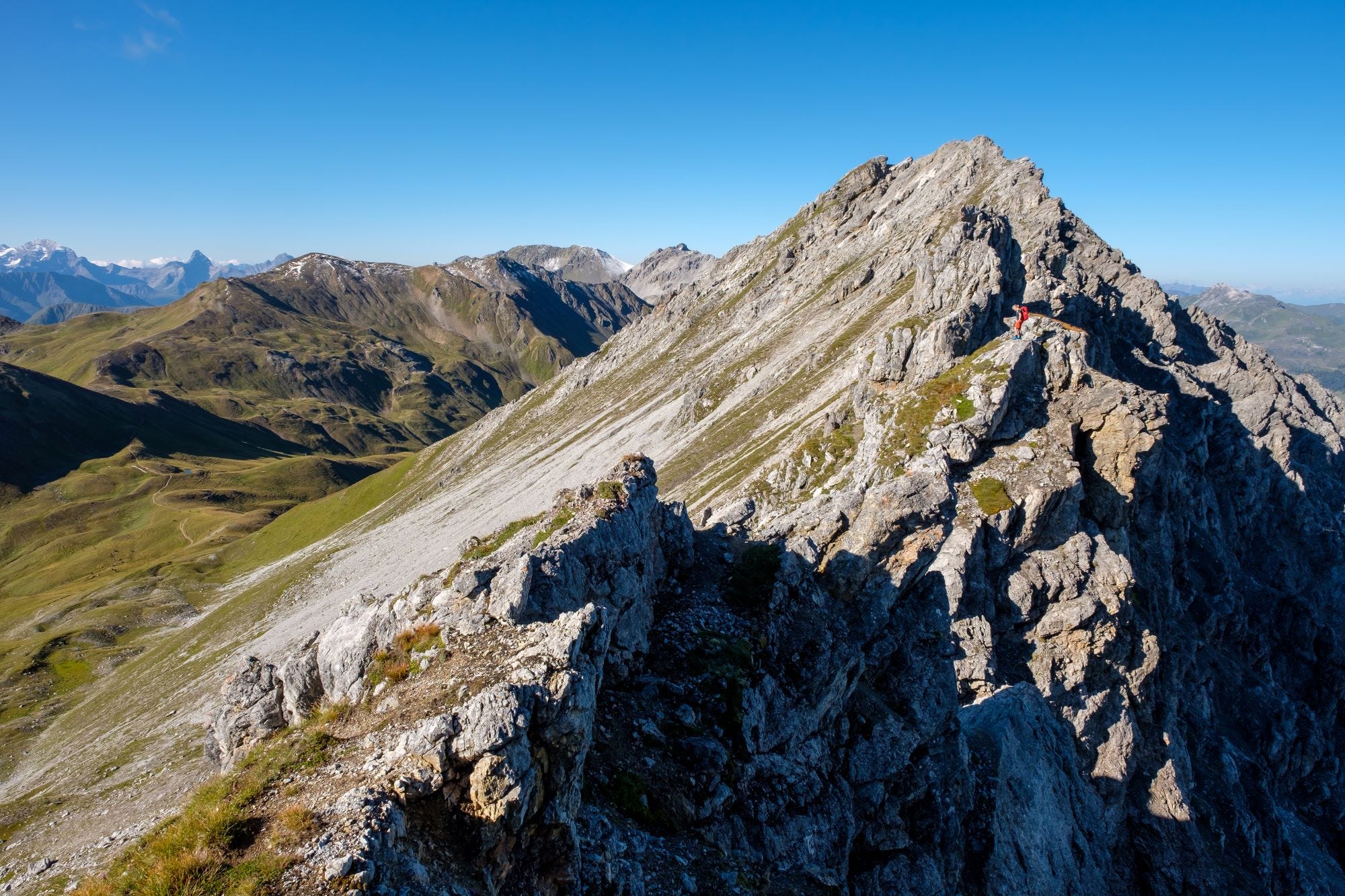
The ridge routes from Davos to Bergün
We see the peaks of Appenzell with Säntis and Altmann in the northeast, the Glarus Alps with Tödi in the northwest, followed by the Bernese Alps with Finsteraarhorn, in the south the ice bastion of the Bernina massif. Nearby, a mountain that looks outrageously like the Matterhorn catches the eye. That's why the Tinzenhorn is often called the Matterhorn of Davos. In its direction Dieter and I want to hike, from Davos to Bergün, from ridge to ridge, a brilliant 4-day tour through an enormous variety.
The fascinating geology of the Graubünden mountains
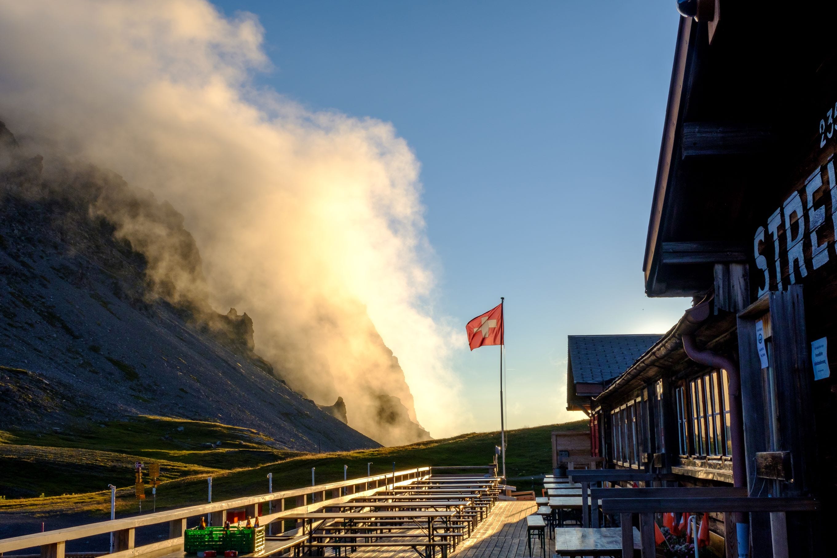
The rock layers and types alone make the mountains appear colorful. Their mosaic of colors and shapes is fascinating. The collision of the continental plates during the folding of the Alps has pushed almost two dozen different rock layers on top of each other, folded, recrystallized. A first impression of this is demonstrated by the Strelahorn. Klaus Schuster told us about this great ridge route last year. The landlord of the mountain hut on the Strelapass occasionally allows himself the tour on the mountain in front of his nose. Demanding and exactly the right terrain is that for his Falco and means a mongrel dog with unbridled energy. Even the sign at the entrance to the house "Dog and master please do not feed" betrays a humorous disposition.
A Walser on the magic mountain
Having quickly turned one's back on the flattened slopes at the Weissfluhjoch, the eye can once again rejoice at the nearby Strelapass. To the west, one looks into the untouched Fondei. Thanks to the initiative of its inhabitants, an expansion of the Davos ski area could be prevented and the dreamy high valley gives itself up to mountain railroads and hype. Once inhabited by Walsers, the typical archaic settlements scattered over the open pastureland can be recognized from a distance. "I, too, am a Walser," Klausi emphasizes, not without pride. Shirt-sleeved, he stands outside on the terrace of his mountain hut on the Strelapass - even in biting cold, when others have long since pulled on their down jackets. He is not a squeamish fellow, uncomplicated, open and direct - a mountain man. He would come from the Kleines Walsertal and throw jokes. With this, the innkeeper from Austria quickly creates a feel-good atmosphere. The same goes for his cuisine. Everything is homemade, from the Bündner barley soup to the dough for the crispy tarte flambée. You also have to be inventive here, far away. So Klausi's cake always tastes fresh because he bakes it in a jar. "Putting the lid on while it's still hot is like canning," he reveals, "and it lasts forever."
Slow Mountain: between Schatzalp and Strelapass
A cable car once passed through on the Strelapass, but it has been dismantled. "Now everyone has to hike at least an hour to get to me, but I have much happier guests," grins the giant with the cowhide clogs. Cattle graze peacefully around the neat mountain hut, not only maintaining a harmonious cultural landscape but also increasing biodiversity. You hardly notice that the area is used as a ski resort in winter. Just as it used to be with all ski areas. The ski area Slow Mountain is now called between Schatzalp and Strelapass with two retro ski lifts. Matching the nostalgia of the former tuberculosis sanatorium that Thomas Mann literarily catapulted into world history in his "Zauberberg"
From modernity to tradition: The Sertig Valley and the Walserhuus
The next day we take the ridge route from the Jakobshorn over the Jatzhorn into the Sertig valley. You can quickly reach Davos with the Schatzalp cable car and Jakobshorn by cable car. Lots of mountain bikers usually have the same in mind. But you can avoid them shortly after the mountain station on a narrow ridge trail that offers silence and pure panoramic bliss. Like a string, it threads its way between the Dischma and Sertig valleys to Tällifurgga, where you meet the "Walserweg". Instead of descending from there, we add the Tällihorn. Suddenly the view falls into the Sertig. The picture-book village lies enchanted in the poison-green valley floor in front of the mighty mountain backdrop of Hoch Ducan. The Sertig village seems to have fallen out of time. Old yellowed black and white photos hanging in the Walserhuus confirm that nothing has changed. Only the Walserhuus itself. One picture shows it as a spa house. The dust-free, crystal-clear mountain air and the healthy high-altitude climate had attracted lung patients to Davos for a cure at the beginning of the 20th century. Countless sanatoriums were built, which became obsolete in the 1940s with the development of new medicines and were converted into hotels over time. In addition to Schatzalp and Walserhuus, this also includes the Hotel Ducan in Monstein, we note at the end.
A culinary voyage of discovery on the Kurhaus-Trek
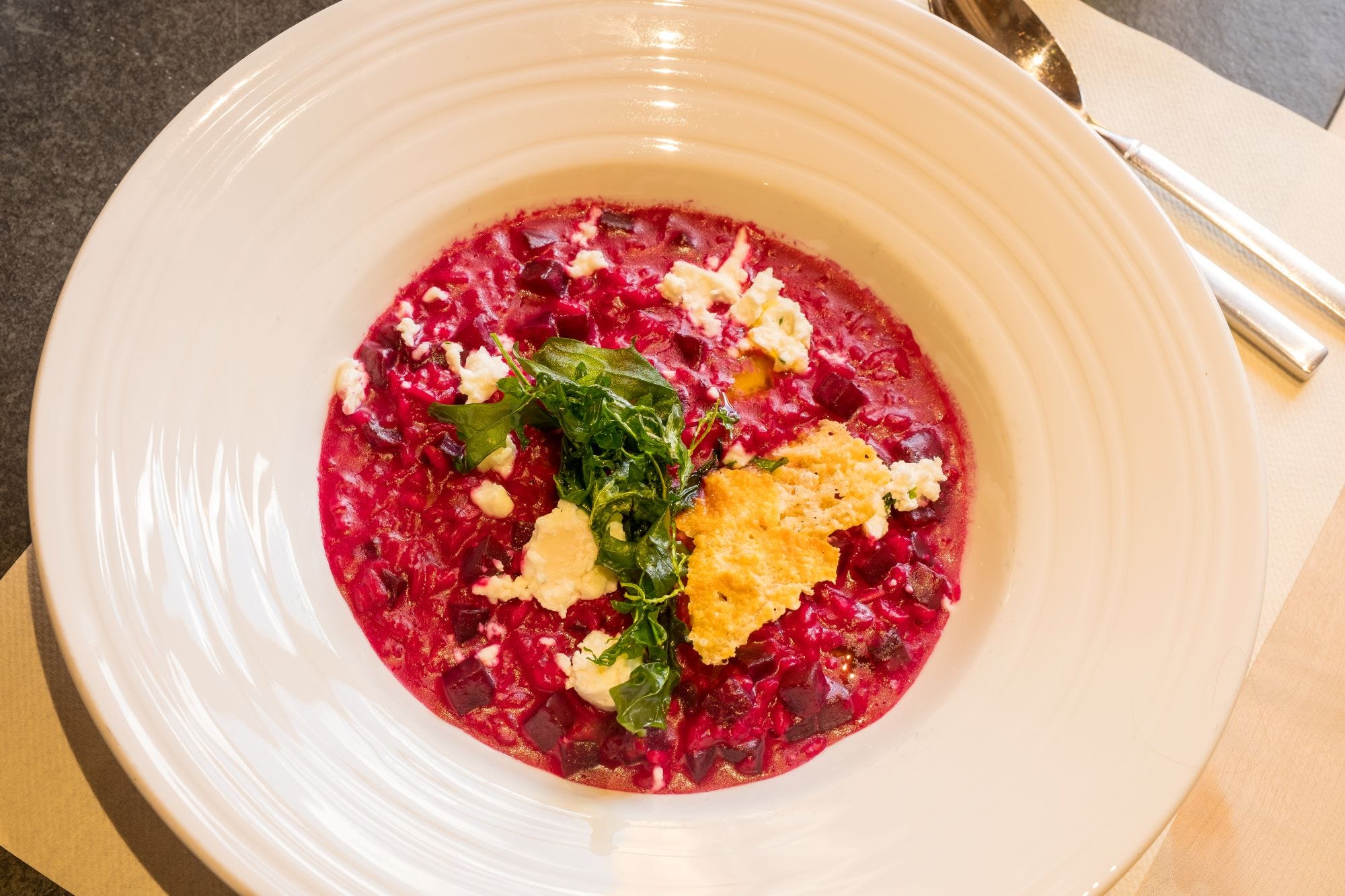
Thus, our ridge route actually turns out to be a Kurhaus trek. Which, as we find, also outed itself as a gourmet trek. The palate is spoiled all along the way. In the Walserhuus with delicious game dishes such as deer carpaccio or Grisons specialties such as Chrutchräpfli. They resemble stuffed ravioli, served in nut butter and with Sertiger Alpengourmet cheese. If you just want to taste the hearty classics maluns, capuns and barley soup, order a triology of manageable size. So still the fine desserts can find place. For digestion an Arvenlikör?
On the route over the Rinerhorngrat and the Marchhüreli on the next day, we learn that the Hubelhütte is located. There a South Tyrolean with extremely tasty kitchen switches and walte. Well, then the break stop would be clear. From there, four panoramic hours later, we reach Monstein. Another picturesque place where you would like to stay longer. Especially since it is the coolest village meeting place par excellence.
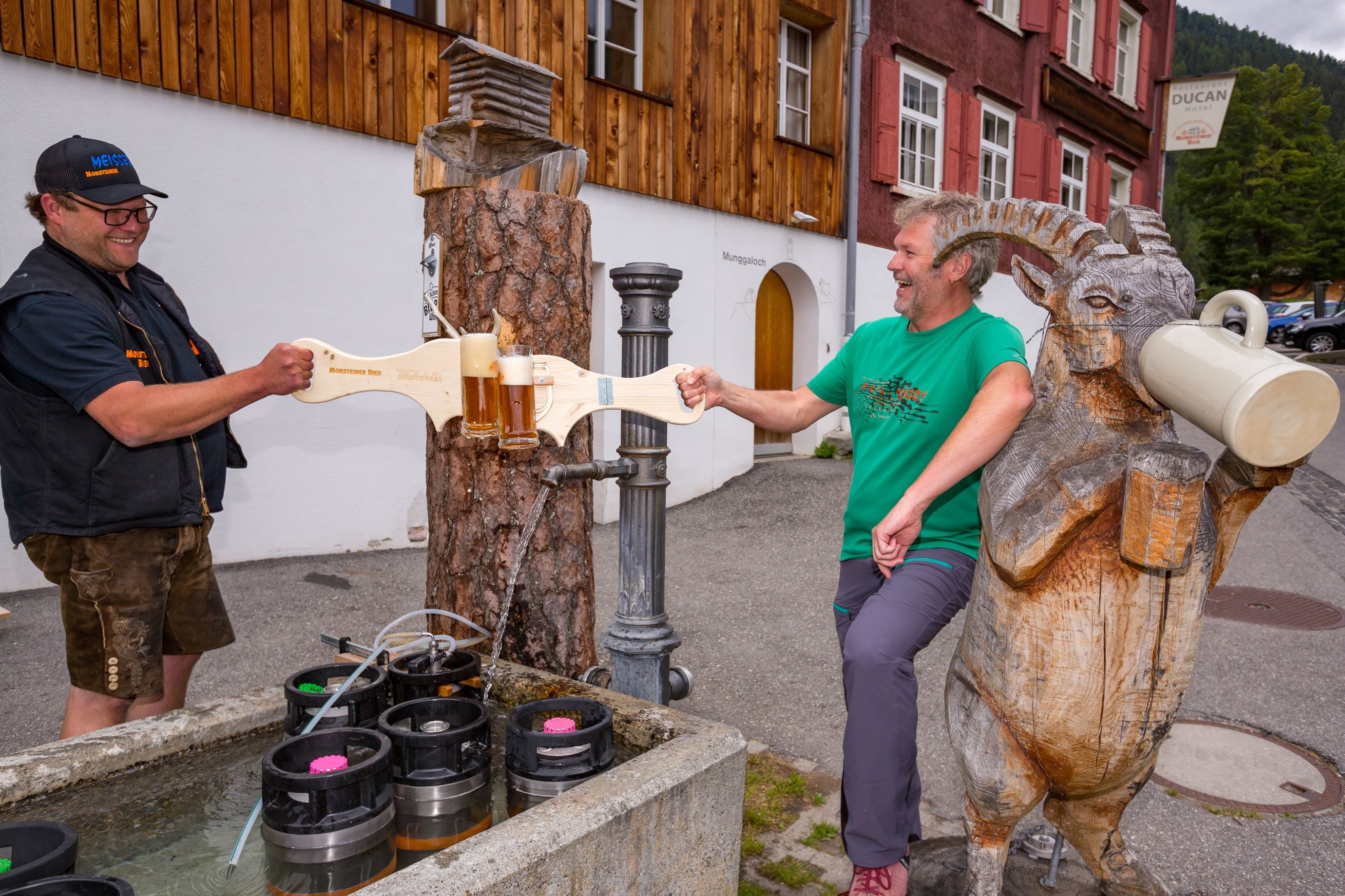
Of Häusträffel, Mungga and Wätterguoge
Sebastian Degen, a brewmaster like you'd imagine him to be, makes sure of that. Full of passion. And it's no surprise that he comes from Bavaria. Basti, as everyone calls him, has been taking care of the Monstein brewery for years and started the "Open House Evening". Every Friday, locals and vacationers alike meet at the beer fountain, which has been established since the days of Corona, and toast each other with beer specialties whose funny names are enough to make you laugh, such as Häusträffel (the Grisons word for grasshopper), Mungga (= marmot) or Wätterguoge (= Alpine salamander) Weizen. At the hostel next to it, the Hotel Ducan, it also says "last beerstop before heaven!" The tasty treats from innkeeper Benni Schibli go well with the Monstein beer. Even entire dishes are created with the hop juice, such as salads with homemade beer dressing, Wätterguoge beer goulash of local beef with thyme-bacon beans and paprika spaetzli. And for dessert, perhaps a roasted malt cream? How fortunate that the next burr route acts as the best calorie burner.
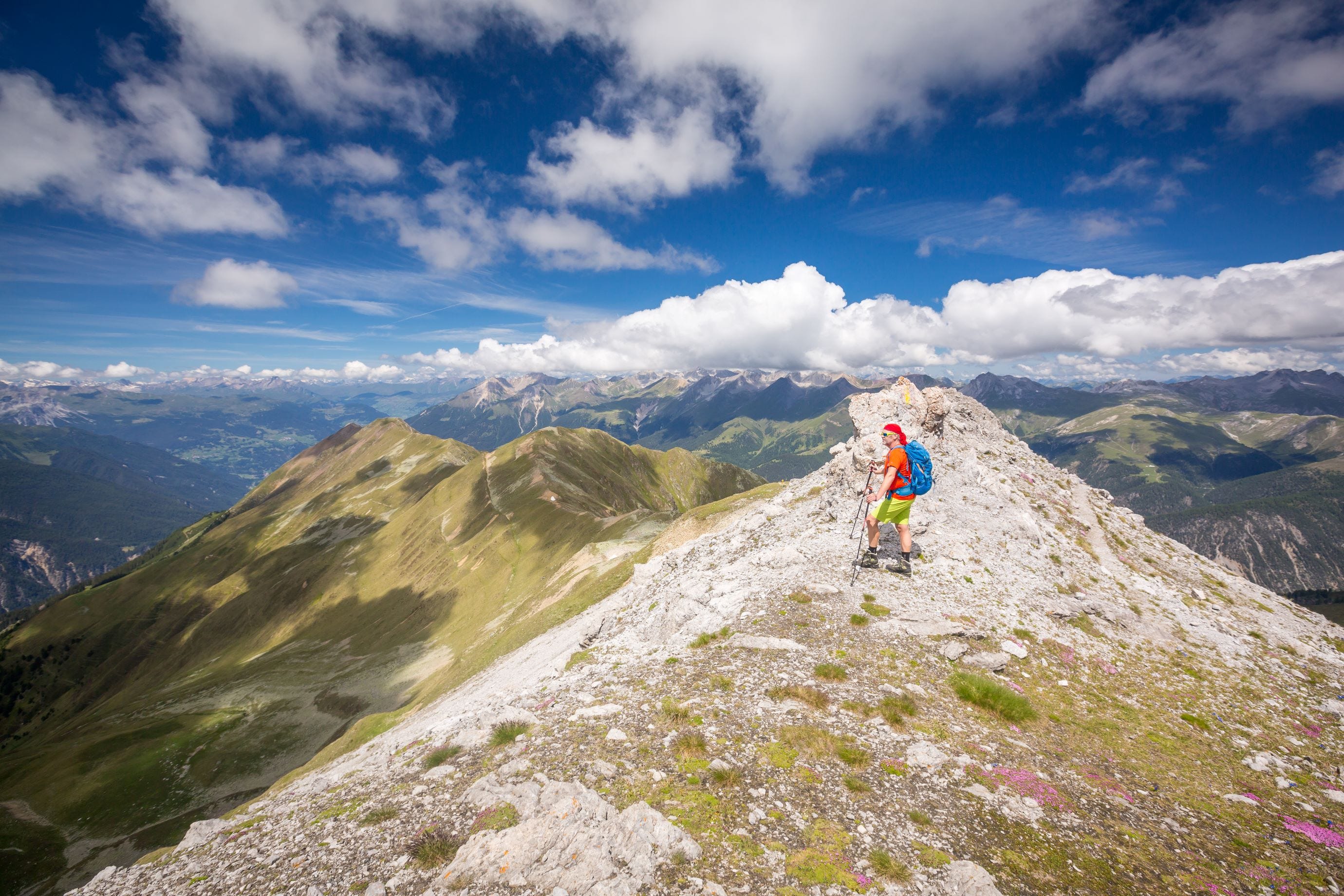
The Büelenhorn and the Stulsergrat: A final adventure
The route over Büelenhorn and Stulsergrat to Bergün eats up a fair amount of altitude and hours. But what a short trip. Since there is no cable car nearby, there are usually only a few fellow hikers. At the same time, there is so much scenic variety that one should start early in order not to get into time pressure. How mighty the Tinzenhorn looks from the Stulsergrat. It towers proudly above the Albula Valley, as if to say: I am freer than my overcrowded colleague in the Valais - the difference between fast and slow mountains. It goes without saying that I will climb the Tinzenhorn one day.
Graubünden for ridge walkers - information on how to get there and worthwhile routes
Arrival
Ideal with public transport. Train journey through beautiful landscape to Davos and back from Bergün (www.sbb.ch). At the train station in Bergün it is worth visiting the railroad museum (www.bahnmuseum-albula.ch).
Information
Davos Tourism, Tel. +41 (0)81 415 21 21, www.davos.ch
Bergün Filisur Tourism, tel. +41 (0)81 407 11 52, www.berguen-filisur.ch
Literature
Gratwandern Südschweiz, Iris Kürschner and Bernd Jung, Bergverlag Rother, to be published in spring 2024.
Strela (2636 m)
Walking time: 2.30 hrs.
Difference in altitude: 300 m.
Requirements: T3+. Exposed in the summit area, where you have to use your hands now and then. The extension (2 hrs) over the Chüpfenflue (2682 m) a bit more demanding if you avoid the ridge rocks T4, otherwise T5.
Starting and end point: Strelapass, 2350 m. Approach from Schatzalp mountain station (1.30 hrs) or from Parsenn middle station via the very beautiful Panoramaweg (1 hr) or from Weissfluhjoch mountain station (0.45 hrs).
Accommodations: Mountain hut Strelapass, Tel. 081 415 52 67, www.strelapass.ch
Hotel Schatzalp, Tel. 081 415 51 51, www.schatzalp.ch
Map: Swisstopo 1:50,000, sheet 248T Prättigau.
Jakobshorn - Tällifurgga - Sertigtal/ Walserhuus
Walking time: 3.30 hrs (with detour Tällihorn 0.45 hrs additional)
Difference in altitude: 120 hm in the ascent, 840 hm in the descent
Requirements: T3, at the Jatzhorn somewhat exposed. If the ridge is bypassed on the high trail then T2.
Starting point: Jakobshorn mountain station (2590 m). Access from Davos-Platz.
End point/accommodation: Hotel Walserhuus in the Sertigtal, Tel. 081 410 60 30, www.walserhuus.ch
Map: Swisstopo 1:50.000, sheet 248T Prättigau as well as sheet 258T Bergün.
Rinerhorngrat and Marchhüreli (2578 m)
Walking time: 6 hrs.
Difference in altitude: 740 Hm in ascent, 980 Hm in descent.
Requirements: T2, comfortable ridge tour on narrow path with only one exposed spot at Marchhüreli, which can also be bypassed. On the first and the last third the route has to be shared with mountain bikers, therefore best to avoid weekends.
Starting point: Walserhuus in the Sertig valley.
End point/accommodation: Hotel Ducan in Monstein (1626 m).
Map: Swisstopo 1:50.000, sheet 258T Bergün.
Büelenhorn (2807 m) and Stulsergrat
Walking time: 8.30 hrs.
Difference in altitude: 1200 hm in ascent, 1500 hm in descent.
Requirements: T3, a few exposed sections.
Starting point: Monstein (1626 m).
End point: Bergün (1373 m).
Map: Swisstopo 1:50.000, sheet 258T Bergün.
-
Asymmetric 42+8 trekking backpack€200.00Incl. VAT, plus shipping free delivery
With recycled PET bottles
-
Asymmetric 38+8 trekking backpack women’s€200.00Incl. VAT, plus shipping free delivery
With recycled PET bottles
-
Asymmetric 48+8 trekking backpack women’s€220.00Incl. VAT, plus shipping free delivery
With recycled PET bottles
-
Avox 75+10 trekking backpack€320.00Incl. VAT, plus shipping free delivery
With recycled PET bottles
-
Astrum EVO 70+10 trekking backpack€250.00Incl. VAT, plus shipping free delivery
With recycled PET bottles
-
Ahead 48+ backpacking backpack€230.00 €184.00Incl. VAT, plus shipping free delivery
Using recycled scrap tires
-
Avox 65+10 trekking backpack€300.00Incl. VAT, plus shipping free delivery
With recycled PET bottles
-
Hidalgo 42+8 children`s backpack€150.00Incl. VAT, plus shipping free delivery
With recycled PET bottles
-
Astrum EVO 60+10 trekking backpack€230.00Incl. VAT, plus shipping free delivery
With recycled PET bottles
-
Astrum EVO 55+10 liters trekking backpack women’s€230.00Incl. VAT, plus shipping free delivery
With recycled PET bottles
-
Asymmetric 52+8 liters trekking backpack€220.00Incl. VAT, plus shipping free delivery
With recycled PET bottles
-
Avox 60+10 trekking backpack women’s€300.00Incl. VAT, plus shipping free delivery
With recycled PET bottles
-
Ahead 44+ backpacking backpack women’s€230.00 €184.00Incl. VAT, plus shipping free delivery
Using recycled scrap tires